Mount Allison holds first GIS Day Nov. 16
 Mount Allison University is hosting its first-ever GIS Day on Wednesday, Nov. 16.
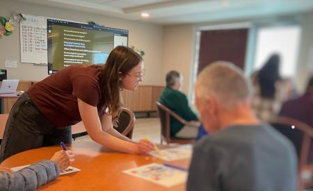
The event helps promote and explain a little more about GIS — geographic information systems — and its applications. Mount Allison offers a GIS minor, with approximately 60 students each year enrolled in GIS courses.
The need for GIS continues to grow, in part due to its wide relevance for solving problems like determining the best location to place everything from a business to a solar panel or helping medical professionals identify and monitor disease outbreaks.
Geography and Environment Professor Dr. David Lieske and Social Sciences technician Christina Tardif are co-organizing the GIS Day event at Mount Allison. Lieske says innovations in remote sensing — like new satellites and personal drones — are contributing to an ever-increasing volume of data that can be studied using GIS.
“Technology is driving a need for specialists who can process this data,” he says. “There are huge opportunities for graduates who have knowledge of GIS and computing, and who have expertise in spatial analysis. It’s one of those things that is going to continue to grow.”
Lieske says GIS is relevant for any discipline or profession concerned with how things happen in space. Currently he is researching marine risks to seabirds in Atlantic Canada as well as collaborating with Dr. Vett Lloyd, a Mount Allison biology professor, to better understand the current and potential future spread of black legged ticks in southeastern New Brunswick.
“My research involves building computer models to identify the factors that determine where species occur, but also mapping how those distributions might change in the future,” he says. “I couldn’t do my research without GIS.”
GIS is also widely used in social research to track patterns of social vulnerability, public opinion, human activity, or to assess access to services.
The GIS Day event runs from 10:30 a.m. to 12 p.m. in Room 115 of the Avard-Dixon Building at Mount Allison University.
Guest speaker Brian Herteis, who works for the Municipality of Cumberland, will talk about how he used GIS technology to map the geothermal infrastructure and green energy potential of abandoned coal mines in Springhill, NS. GIS students will speak about their experiences with the discipline and the summer job opportunities it presented.
Participants will also get a tutorial on map making.
“We want to show how easy it is to make a map in GIS. In just a few steps, you can produce some very beautiful looking maps,” Lieske says, explaining students and faculty often need to present a map in their papers and reports.
“But I’d say drawing a map is only the beginning of what you can do with it,” he says. “The most important thing it does is answering questions you would not otherwise be able to answer. You may want to know where all the houses or roads or forests are in a particular area. You can identify and classify data like that by hand, but it is slow and tedious. GIS gives you the power to ask sophisticated questions.”
The GIS Day events are free and all are welcome to attend.
For more information about GIS Day, visit: http://www.mta.ca/gisday
For more information about the GIS minor at Mount Allison, visit: https://www.mta.ca/programs/gis/
Photo caption: Dr. David Lieske teaches a GIS class at Mount Allison.