Anthropology students present Indigenous Map Exhibition
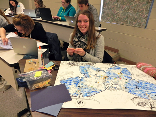
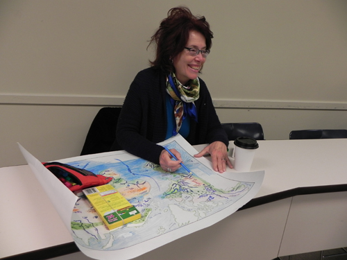
 Dr. Paulette Steeves, a Cree-Metis professor and Indigenous anthropologist/archaeologist at Mount Allison University, created a semester-long assignment for her students to help them to better understand Indigenous people, places, and events and their connection to the land.
“In Indigenous ways of being, knowing, and doing, the land is central to life and education,” says Steeves. “I cannot always take students to all the places that we study so I developed this assignment where each student creates a map over the course of the semester from a database they also develop.”
The maps will be on display in Tweedie Hall in the Wallace McCain Student Centre on Nov. 28 and 29 from 9 a.m.-6 p.m. Steeves will answer questions about the project from 2-4 p.m. on November 28.
Steeves’ own research looks at the history of Indigenous people during the Pleistocene period in the Western Hemisphere. According to Steeves, Indigenous people were present in the Western Hemisphere as early as 60,000 years ago, far earlier than previously thought.
Her other area of research is on decolonizing academia, knowledge production, and Indigenizing curriculum. She describes this as weaving Indigenous method, theory, and knowledge into Western educational institutions.
 “Colonization, attempted genocide, dispossession and education have erased Indigenous people from place and time in many areas of the world,” she says. “It is important for students to realize the existence of these colonial ideologies and to un-do some of the damage done. By matching Indigenous populations, knowledge, languages and oral traditions with the land through these maps, students are learning many important lessons.”
These lessons include the history and importance of reclamation and repatriation and on how these students can be a part of the healing process for all communities.
“Though Indigenous communities continue to suffer the impacts of colonization it is not just an Indigenous issue, it is a Canadian issue,” says Steeves.
Students appreciate that the maps contribute to their learning in some unexpected ways.
“I enjoy putting the skills I have learned from drawing class towards other academic subjects and I think exploring these subjects through a medium other than an essay has given me the chance to understand them in a different and probably more permanent way. I'm all for interdisciplinary projects,” says anthropology student Saskia Van Walsum.
Student Elizabeth Glenn–Copeland says the project has been an amazing experience in many ways.
“As a professional storyteller, I have delved into the world of folklore and expected that this class would be enjoyable, and that it would add to my knowledge base,” she says. “Both of these expectations were met, but there is so much more. Dr. Steeves’ style of teaching really encourages the kind of curiosity that makes learning go deep. The experiential nature of the mapping assignment took my understanding of various cultural folklore traditions to a new level and has given me a tool I can refer to in the years ahead.”
Steeves is impressed with the creativity and diversity of approaches to the assignment that she has seen, with no two maps alike.
Photo captions: Students Saskia Van Walsum and Elizabeth Glenn-Copeland


